- You cannot add another "Views in Third Congressional District - Schori & Lehmann Brewery in Elgin, Court House in West Union and Residence of Hon. P.G. Baily in Grand Meadow" to your cart. View cart
Sale!
 |
||
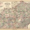
Kentucky and Tennessee
In stock
This hand colored map was made by O.W. Gray and Son in 1882 for “The National Atlas”. This map illustrates Kentucky and Tennessee. In the insets, the map shows systems of railroads, the density of population of both states, the hypsometric sketch, and the comparative increase of the populations of both areas. Sections of the city are distinguished by bright pastel color. Other details include the names of streets, important parks, and illustrations of railroads and rivers.
Size: 25.75 x 15.75 inches
Condition: Very Good
Map Maker: O.W.Gray and Son
Coloring: Original Hand Color
Year: 1882
Condition: Very Good
Map Maker: O.W.Gray and Son
Coloring: Original Hand Color
Year: 1882
In stock