- You cannot add another "Counties of Whiteside, Henry, and Bureau, Illinois" to your cart. View cart
 |
||
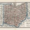
Ohio
In stock
This map of Ohio was published by The Bankers and Attorneys Register in 1889. This is the first time we have encountered these maps in our 30 years of collecting. Henry Stebbins was the engraver.
Size: 12.75 x 9.25 inches
Condition: Excellent
Map Maker: Henry S. Stebbins
Coloring: Printed Color
Year: 1889
Condition: Excellent
Map Maker: Henry S. Stebbins
Coloring: Printed Color
Year: 1889
In stock