- You cannot add another "Views in Third Congressional District - Schori & Lehmann Brewery in Elgin, Court House in West Union and Residence of Hon. P.G. Baily in Grand Meadow" to your cart. View cart
 |
||
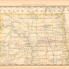
Map of Dakota – Northern Portion
In stock
This antique map originally appeared in the “Historical Hand-Atlas” produced in 1881 by H.H. Hardesty & Co. These maps show many details including cities and towns, lakes and rivers, and most important the existing railroad network. Each railroad is designated by a black or red line, which is also labeled with the name of the railroad.
Size: 19 x 13 inches
Condition: Very Good
Map Maker: H.H. Hardesty & Co.
Coloring: Lithographic Coloring
Year: 1881
Condition: Very Good
Map Maker: H.H. Hardesty & Co.
Coloring: Lithographic Coloring
Year: 1881
In stock