- You cannot add another "Views in Third Congressional District - Schori & Lehmann Brewery in Elgin, Court House in West Union and Residence of Hon. P.G. Baily in Grand Meadow" to your cart. View cart
 |
||
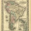
Map of South America Showing its Political Divisions ‘
In stock
S. Augustus Mitchell Jr. made this hand colored map for “Mitchells New General Atlas” in 1872. South America is illustrated on this map, with an inset map showing the proposed Atrato-Inter-Oceanic Canal Routes, for Connecting the Atlantic and Pacific Oceans. Regions are distinguished by bright pastel colors. Deserts, lakes, mountains, rivers, important cities and countries are identified. Surrounding the beautifully hand colored map is the characteristic ‘ inch ivy style border.
Size: 10.5 x 13 inches
Condition: Very Good
Map Maker: S. Augustus Mitchell
Coloring: Original Hand Coloring
Year: 1872
Condition: Very Good
Map Maker: S. Augustus Mitchell
Coloring: Original Hand Coloring
Year: 1872
In stock