- You cannot add another "Gulf of Venezuela, Peninsula de Guajira, Castilletes Anchorage and Approaches" to your cart. View cart
 |
||
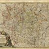
Lotharingiae Tabula Generalis in qua Ducatus Lotharingiae et Barri nec non Metensis, Tullensis et Verdunensis Episcopatus [Eastern France]
In stock
A stunning map of the Lorraine region of France centering on Metz.Amazing detail on this early 18th century map.
Size: 22 x 19 inches
Condition: Excellent
Map Maker: Johann Baptist Homann
Coloring: Original Hand Coloring
Year: 1716
Condition: Excellent
Map Maker: Johann Baptist Homann
Coloring: Original Hand Coloring
Year: 1716
In stock