- You cannot add another "Views in Third Congressional District - Schori & Lehmann Brewery in Elgin, Court House in West Union and Residence of Hon. P.G. Baily in Grand Meadow" to your cart. View cart
 |
||
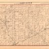
Lancaster, Indiana
In stock
This antique map originally appeared in the “Historical Hand-Atlas” produced in 1881 by H.H. Hardesty & Co. The Atlas had nine Farm Maps, or Townships, of Wells County Indiana. Shown here is the township of Lancaster.
Size: 12.75 x 9.75 inches
Condition: Very Good - some age toning
Map Maker: H.H. Hardesty & CO.
Coloring: Hand colored engraving
Year: 1881
Condition: Very Good - some age toning
Map Maker: H.H. Hardesty & CO.
Coloring: Hand colored engraving
Year: 1881
In stock